National flag SVG collections are widely available online, but few provide any provenance. Where did that particular shade of blue come from — a government specification, a Wikipedia edit, or someone’s best guess? I wanted to find out.
Constructible Flags is a Haskell project that generates flag SVGs programmatically from official specifications, using straightedge-and-compass-style geometric constructions where possible, with full provenance for every value. It’s not particularly useful, but I find it interesting. Inspired by Dr Zye’s video on the constructibility of flags, and my earlier write-up on ruler & compass constructions.
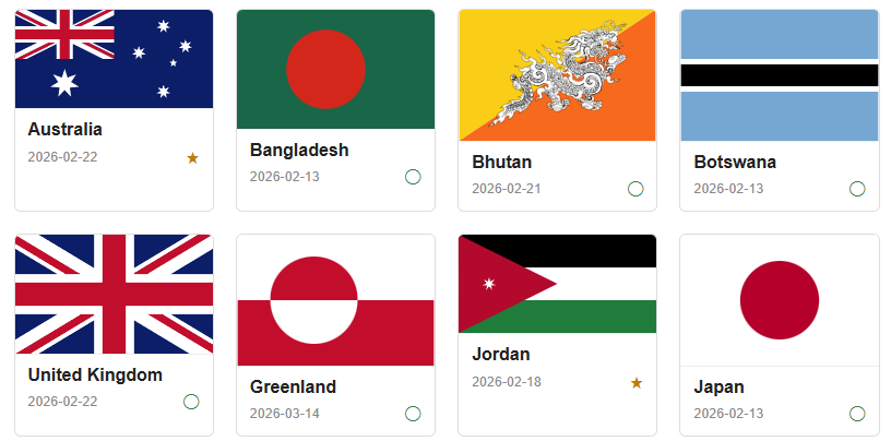
Fourteen flags have been implemented so far, ranging from France (three rectangles) to Nepal (the world’s only non-rectangular national flag.) Some governments are remarkably precise — Nepal’s constitution includes a full geometric construction. Others are surprisingly vague — France’s constitution says “blue, white, red” and the rest has been left to design guidelines that have changed over the years.
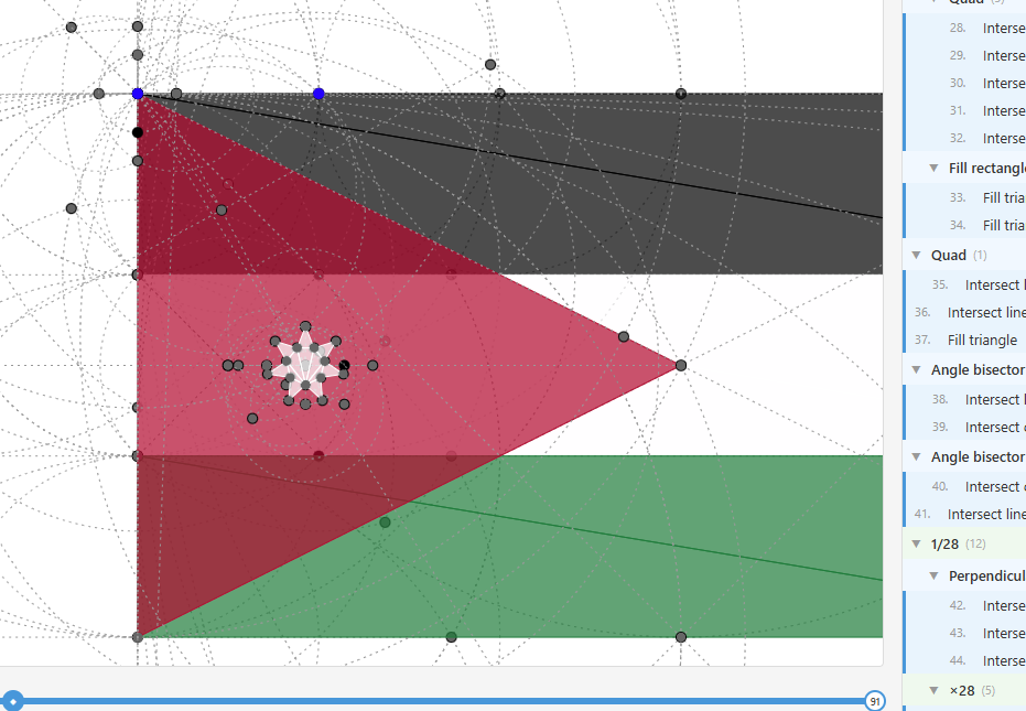
Every flag on the site has a step-by-step construction viewer. You can scrub through each geometric step and watch construction circles, lines, intersection points, and fills accumulate. This was invaluable during development — when a diagonal line is slightly off, being able to scrub to the exact intersection step that went wrong is much more productive than staring at a final SVG.
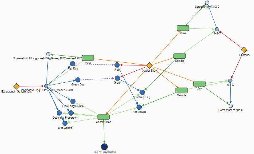
Every colour, proportion, and layout is sourced from legislation, constitutional schedules, official design guidelines, with editorial decisions clearly documented. The project provides W3C PROV-JSON for each flag, recording exactly where every value came from. Bangladesh is a good example: the official specification names dyes (“Procion Brilliant Green H-2RS”), which I editorially map to Pantone codes, which are then converted to RGB values by sampling Pantone’s website. Each link in that chain is recorded.
Design Choices
The heart of the project is a free arrow (FlagA a b) encoded as a GADT. Flags are defined using Haskell’s proc notation, which makes them read like geometry instructions:
design :: Sourced :> es => Eff es (FlagA (Point, Point) Drawing)
design = do
    (h, w) <- reference "2:3 proportion" flagLaw (2, 3)
    discRatio <- reference "Disc height" flagLaw (3 % 5)
    whiteColor <- impliedReference "White" flagLaw (sRGB24 255 255 255)
    redColor   <- impliedReference "Crimson" flagLaw (sRGB24 188 0 45)
    pure $ proc origin -> do
        (tl, tr, br, bl) <- boxNatural w h -< origin

        center <- intersectLL -< ((tl, br), (tr, bl))
        top <- midpoint -< (tl, tr)
        edge <- rationalMult discRatio -< (center, top)

        bg <- fillRectangle whiteColor -< (tl, tr, br, bl)
        disc <- fillCircle redColor -< (center, edge)

        returnA -< bg <> disc
Why an Arrow instead of a Monad? An Arrow’s structure is inspectable before you run it. With a monadic computation, the structure of the next step can depend on the result of the previous one — you can’t know what comes next without executing it. With an Arrow, the entire computation is a static data structure. The same FlagA value gets interpreted multiple ways: eval produces SVG geometry, steps extracts a flat list of primitives for cost counting, evalTree records each step for the interactive viewer, and evalLabels collects named points. Add a new flag and you automatically get all of those outputs from one proc block.
This matters because the construction steps are the point. Consider how midpoint is implemented:
midpoint :: FlagA (Point, Point) Point
midpoint = group "Midpoint" $ proc (a, b) -> do
  -- Two circles of equal radius (|ab|) centered at a and b
  (p, q) <- intersectCC -< ((a, b), (b, a))
  -- The line (p, q) is the perpendicular bisector; intersect with (a, b)
  m <- intersectLL -< ((p, q), (a, b))
  returnA -< m
This is not (a + b) / 2. It’s the classic compass-and-straightedge construction: draw two circles of equal radius, connect their intersections to get the perpendicular bisector, then intersect with the original segment. Same point, but the construction is visible in the data structure and in the interactive viewer.
Provenance is handled with a custom algebraic effect Sourced built on the effectful library. Flag definitions carry a Sourced :> es constraint and source their values with calls like reference and impliedReference. The same code runs under different interpreters: runSourcedPure strips the metadata and just returns values for rendering, while runSourcedCollect accumulates every sourced element for the PROV-JSON generator. The flag definition doesn’t change; only the interpreter does.
I initially tried representing all coordinates with exact algebra — constructible numbers are algebraic, so in principle you could avoid floating-point entirely. In practice, this led to exponential blowups (expressions like sqrt(2) + sqrt(3) nested through hundreds of construction steps). So I backed off to Double as the computational substrate, but kept a Field tag tracking what algebraic field each number should inhabit: FInteger, FRational, FIrrational, and so on. The tag propagation is conservative — cos(π/3) = 0.5 gets tagged FCyclomatic even though the result is rational — but it gives some insight into the mathematical character of each construction while keeping things tractable. It also serves as an abstraction layer if I ever want to try exact algebra again.
Constructibility
In classical geometry, a constructible figure is one you can draw with only an unmarked straightedge and a compass. You can bisect angles, find midpoints, draw perpendiculars — all without measuring. A lot of flag geometry falls into this category.
The project uses three geometric primitives that correspond to what a straightedge and compass allows: line-line intersection, line-circle intersection, and circle-circle intersection. Some flags are fully constructible this way, for example Japan, France, Bangladesh, and Greenland. Others require NGonVertex for regular polygons that can’t be constructed with compass and straightedge, like Australia or Jordan’s 7-pointed stars. Some, like Bhutan, use SVGOverlay for non-geometric elements like coats of arms. The site badges each flag with its construction methods and total step cost so you can see at a glance what’s involved. A complete list of geometry and rendering primitives is documented here.
The source is on GitHub and the site is live at flags.xaviershay.com.